


News

Weather
Posted: Apr 03, 2024 9:56 AMUpdated: Apr 03, 2024 9:59 AM
NWS Confirms 5 EF-1 Tornadoes in Monday's Storms

.jpg)
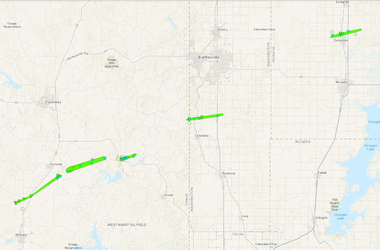
The National Weather Service has confirmed five tornadoes touched down Monday in Osage, Washington and Nowata counties — all were rated as EF1s.
The first tornado of the evening touched down 2 miles north of Hominy at 7:17 p.m. The twister stayed on the ground for 10 minutes, traveling 7 miles with maximum winds of 110 mph.
The second tornado began at 7:28 p.m., touching down 2 miles southeast of Wynona. It caused damage for 8 minutes and traveled 5.5 miles. Maximum winds reaching 110 mph were observed based on damage.
A third twister touched down at 7:38 p.m. in Barnsdall. The tornado caused damage to structures in the eastern portion of town, staying on the ground for more than 2 miles before dissipating 4 minutes later. Maximum wind gusts of 100 mph were observed.
The fourth tornado of the evening began at 7:49 p.m., 3 miles northwest of Ochelata. It traveled nearly 5 miles, crossed over Highway 75 and then dissipated 4 miles northeast of Ochelata. Maximum winds observed were measured at 110 mph.
The fifth tornado began at 8:13 p.m., 2 miles northwest of Delaware. The tornado stayed on the ground for approximately 4 miles, crossing Highway 169 in the process before lifting at 8:19 p.m.
Confirmed tornado paths
Below are the official details and observations from the National Weather Service
HOMINY OKLAHOMA TORNADO
Rating: EF1
Estimated Peak Wind: 100 to 110 mph
Path Length /statute/: 7.0 miles
Path Width /maximum/: 600 yards
Fatalities: 0
Injuries: 0
Start Date: 04/01/2024
Start Time: 07:17 PM CDT
Start Location: 4 N Hominy / Osage County / OK
Start Lat/Lon: 36.4763 / -96.4089
End Date: 04/01/2024
End Time: 07:27 PM CDT
End Location: 2 SE Wynona / Osage County / OK
End Lat/Lon: 36.5295 / -96.3013
Survey Summary:
This tornado developed near the intersection of County Road 5408 and County Road 5257, and moved east-northeast. It crossed Highway 99, moved northeast and dissipated after crossing County Road 2701. Numerous trees were uprooted or snapped, most heavily west of Highway 99, and numerous power poles were blown down. This tornado produced a tornadic debris signature from the KINX WSR-88D.
WYNONA OKLAHOMA TORNADO
Rating: EF1
Estimated Peak Wind: 100 to 110 mph
Path Length /statute/: 5.5 miles
Path Width /maximum/: 1000 yards
Fatalities: 0
Injuries: 0
Start Date: 04/01/2024
Start Time: 07:28 PM CDT
Start Location: 2 ESE Wynona / Osage County / OK
Start Lat/Lon: 36.5385 / -96.2887
End Date: 04/01/2024
End Time: 07:36 PM CDT
End Location: 2 W Barnsdall / Osage County / OK
End Lat/Lon: 36.5628 / -96.1946
Survey Summary:
This tornado developed east of County Road 2665, along the 330 Road. It moved east-northeast and dissipated after crossing County Road 2477. The tornado blew the roof from a garage, uprooted or snapped trees, and blew down numerous power poles. This tornado produced a tornadic debris signature from the KINX WSR-88D.
BARNSDALL OKLAHOMA TORNADO
Rating: EF1
Estimated Peak Wind: 90 to 100 mph
Path Length /statute/: 2.20 miles
Path Width /maximum/: 550 yards
Fatalities: 0
Injuries: 0
Start Date: 04/01/2024
Start Time: 07:38 PM CDT
Start Location: Barnsdall / Osage County / OK
Start Lat/Lon: 36.5583 / -96.1613
End Date: 04/01/2024
End Time: 07:41 PM CDT
End Location: 2 ENE Barnsdall / Osage County / OK
End Lat/Lon: 36.5694 / -96.1242
Survey Summary:
This tornado developed just east of Highway 11, over the southeastern side of Barnsdall. It damaged homes, destroyed outbuildings, and blew down trees and power poles as it moved east-northeast, dissipating north of County Road 2400 and west of County Road 2335.
OCHELATA OKLAHOMA TORNADO
Rating: EF1
Estimated Peak Wind: 95 to 105 mph
Path Length /statute/: 4.9 miles
Path Width /maximum/: 550 yards
Fatalities: 0
Injuries: 0
Start Date: 04/01/2024
Start Time: 07:49 PM CDT
Start Location: 3 NW Ochelata / Osage County / OK
Start Lat/Lon: 36.6335 / -96.0079
End Date: 04/01/2024
End Time: 07:56 PM CDT
End Location: 4 NE Ochelata / Washington County / OK
End Lat/Lon: 36.6436 / -95.9205
Survey Summary:
This tornado developed just west of the Osage/Washington County line, between the 2700 Road and the 2600 Road. It moved just north of east, and dissipated east of Highway 75 and south of the 2500 Road. The tornado damaged outbuildings, uprooted trees, and blew down power poles.
DELAWARE OKLAHOMA TORNADO
Rating: EF1
Estimated Peak Wind: 90 to 100 mph
Path Length /statute/: 4.2 miles
Path Width /maximum/: 600 yards
Fatalities: 0
Injuries: 0
Start Date: 04/01/2024
Start Time: 08:13 PM CDT
Start Location: 2 WNW Delaware / Nowata County / OK
Start Lat/Lon: 36.7883 / -95.6713
End Date: 04/01/2024
End Time: 08:19 PM CDT
End Location: 3 NE Delaware / Nowata County / OK
End Lat/Lon: 36.8026 / -95.5974
Survey Summary:
This tornado developed just north of the 1600 Road and west of the 4120 Road. It moved east-northeast across the 4130 Road, Highway 169, and the 4150 Road. It dissipated over open country north of the 150 Road and west of the 4160 Road. Trees were uprooted, large tree limbs were snapped, outbuildings were damaged, and power poles were blown down within the tornado path.
EF Scale: The Enhanced Fujita Scale classifies tornadoes into the following categories:
EF0.....65 to 85 mph
EF1.....86 to 110 mph
EF2.....111 to 135 mph
EF3.....136 to 165 mph
EF4.....166 to 200 mph
EF5.....>200 mph
« Back to News